Cox and Sanders index map of Los Angeles City
Item Overview
- Title
- Cox and Sanders index map of Los Angeles City
- Date Created
- 1896
- Place of Origin
- Los Angeles, Calif.
- Publisher
- Cox and Sanders
- Language
- English
- Collection
- Maps of Los Angeles, California, the United States and the World, circa 1516-1970
Notes
- Description
-
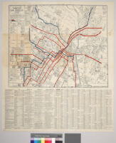
"Showing all streets and street car lines and sewer connections" "Index shows location of streets and shortest routes from centre of city" In lower left hand corner reads: "Compiled in office of Jas. T. Taylor"
Street car lines over printed in red, sewer lines over printed in blue. Tracts are indicated. Railroad lines also indicated. Index to banks, business blocks and halls, theatres, public buildings, public institutions, railway stations, cemeteries, churches, colleges and schools, hotels, parks, telegraph and telephone cos. miscellaneous societies and streets.
Digitization took place as part of the California Cultures Project.
Scale not given.
"Corrected to Jan. 1st 1896"
Physical Description
- Extent
- 1 map
- Dimensions
- 52 x 63.3 cm. on sheet 82.5 x 71 cm.
Keywords
- Genre
-
maps
cartographic - Location
- Los Angeles (Calif.)--Maps
- Resource type
- still image
- Subjects
- Real property--California--Los Angeles--Maps
Find This Item
- Repository
- University of California, Los Angeles. Library Special Collections
- ARK
- ark:/21198/zz00096fkt
- Manifest url
-

Access Condition
- Rights statement
- public domain